|
By Gazette Staff Writers — Thursday, February 20th, 2025
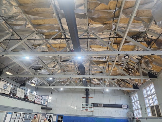 At the Tuesday, January 28, Fillmore City Council Meeting City Council: 1. Approved and authorized the Interim City Manager to sign a contract with Wyatt Trapp Inc. for the Fillmore Boys and Girls Club Building Ceiling Repair Project (“Project”), in the amount of $21,724.08; and 2. Approved a fund transfer in the amount of $25,000.00 to be reallocated from General Fund Reserves Fund 506 to Recreation Fund 304 for the Project. Alternatives: 1. Postpone the Project until the next fiscal year and budget accordingly. 2. Take no action at this time. SR - AWARD OF CONTRACT FOR FILLMORE BOYS AND GIRLS CLUB BUILDING CEILING REPAIR PROJECT.PDF Enlarge Photo |
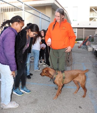
 On January 17, 2025, the Fillmore Boys & Girls Club of SCV, had had a special presentation from Ventura County Search and Rescue K9 (VCSARK9) as part of the “Hug A Tree and Survive” Program. Students learned about the programs and got to meet one of the Search and Rescue K9s. Photo credit Angel Esquivel. Enlarge Photo By Gazette Staff Writers — Thursday, February 20th, 2025
Ventura County Search and Rescue K9 (VCSARK9) brings “Hug A Tree and Survive” Program to Santa Paula Boys and Girls Club and Fillmore Boys and Girls Club In January Team Members Lisa Hammond and Virginia Feyh (and her K9s Velvet and Huck) and volunteers Linda Munday and Angel Esquivel of the Ventura County Search and Rescue K9 Team (VCSARK9) came to talk to the kids (and adults) about the program “Hug A Tree and Survive”. VCSARK9 is a 501c3 nonprofit organization dedicated to the development, training and deployment of high performance, volunteer canine teams which will in turn effectively assist in the search and rescue or search and recovery of missing persons. Hug-A-Tree and Survive was developed in the United States following the search for Jimmy Beveridge in 1981, and was first adapted for Canadian use by the RCMP. It was updated by the National Search and Rescue Secretariat (NSS) and the SAR Volunteer Association of Canada (SARVAC) in 2015 with new videos and activities to support program delivery. Hug-a-Tree and Survive is an AdventureSmart program that helps lost children survive in the woods. It teaches children how not to become lost in the woods, and what to do should they become lost. If a child should become lost in the woods, hugging a tree can help them stay safe, and be found. Staying near a tree offers some protection from the elements, and keeps lost children in the same place, which makes it easier for searchers to find them. The presentation included a short video presentation, discussion about the 4 rules to help keep children safe, and a demonstration with one of the dogs training to be on the VCSARK9 Team, Velvet and Huck, both Redbone [!@#$] Hounds. The Hug-a-Tree Rules Hug-A-Tree and Survive emphasizes four key rules to keeping children safe: Always tell your parents, or another trusted adult where you are going, who you are going with, and when you will be back. You can do this in person, over the phone, through a text message, or by leaving a note in a place they will see it. A tree can help protect you from the elements while you’re outdoors, and most importantly, keep you in one place. Depending on where you are, there may not always be a tree. Perhaps your “tree” can be a large rock or bench at a park, or a sales counter at a mall. No matter what your landmark is, it is important to stay put, in order to stay safe. KEEP WARM AND DRY Temperatures change throughout the day, and can drop at night. Even if you are warm during the day, keep your jacket handy for night time. If you get cold, put on an extra layer, pull up your hood or put on your hat if you have one, tuck your shirt in, tuck pant legs into your socks, and zip up your jacket. You can also keep warm by building a nest to keep you off the ground, or by using an emergency shelter. HELP SEARCHERS FIND YOU BY ANSWERING THEIR CALLS. Whether searchers are parents, police officers, or SAR volunteers, remember they just want to get you home safely. Answer back to their calls by making noise and signaling (remember that whistle!), so you can be heard and seen. Make sure to leave lots of footprints and clues, so searchers can follow your tracks to find you. While designed for the outdoors, these rules are easily transferable to other places including sporting events, shopping malls, public parks, urban areas, and much more! Together, these core points work to ensure kids have the knowledge and training needed to safely enjoy the outdoors, and their communities. For more information about the “Hug A Tree and Survive” program go to https://www.adventuresmart.ca/programs/hug-a-tree-and-survive/. For more information about VCSARK9 go to www.vcsark9.org. This presentation was funded by a grant from the California Fire Foundation https://www.cafirefoundation.orgwhat-we-do/for-grant-seekers |
|
By Gazette Staff Writers — Thursday, February 20th, 2025
 On Saturday, February 15, 2025, a free community event was held on Lemon Way, where over 150 folks gathered. More than 60 toys and bikes were raffled for the kids to win. Pictured are the children receiving their prizes. Pastor Ernie Rangel held a free community event on Saturday, February 15, 2025, at Lemon Way Park, in Fillmore. This was a free event where over 150 people, and more than 60 toys and bikes, were raffled for the kids. Pastor Ernie said, “I grew up in these streets of Fillmore back in the day where my parents didn’t have love for me, so I decided to choose gangs, violence and drugs than to be at home. I want these kids and this community to know that there is a church and a team that care for them and love them, this is why I do this”. Photo credit Pastor Ernie Rangel. Enlarge Photo |
|
By Gazette Staff Writers — Thursday, February 20th, 2025
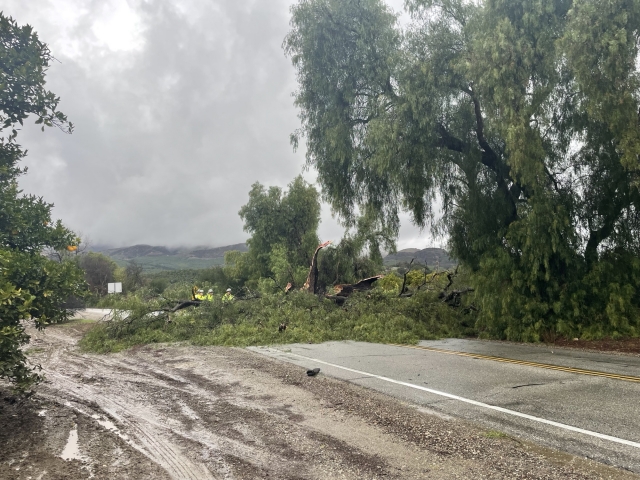 On Thursday, February 13th, at 3:50 p.m., Ventura County Fire Department and California Highway Patrol were dispatched to two trees down on Old Telegraph Road at Cliff Avenue. Ventura County Fire hand crews arrived on-scene with chainsaws. CHP shut the roadway down for over an hour until it was cleared. Photo credit Angel Esquivel. Enlarge Photo |
|
By Gazette Staff Writers — Thursday, February 20th, 2025
FILLMORE, CALIFORNIA – February 5, 2025 – The Fillmore Police Department is urging all community members to prioritize safety on the roads by slowing down and being vigilant, with the aim of safeguarding pedestrians and drivers alike from accidents and injuries. Fillmore Police Chief Malagon emphasizes the importance of road safety, stating, “There’s a lot happening on our roads, and everyone deserves to get to their destination safely. Drivers need to be aware of pedestrians who are out walking. Please slow down and never drive impaired. We all have places to go, so let’s remember that safety is a shared responsibility.” According to data from 2022, the leading primary crash factor for traffic fatalities and serious injuries in California was unsafe speed, accounting for 73.5% of these incidents. To contribute to road safety efforts, the Fillmore Police Department encourages community members to adhere to all traffic laws in the city. Here are some key tips for drivers and pedestrians: For Drivers: Do not exceed speed limits and reduce speed at intersections. Be prepared to yield to pedestrians at marked crosswalks. For Pedestrians: Be predictable. Utilize signalized crosswalks where drivers anticipate pedestrian traffic. Exercise caution when crossing streets, being mindful of approaching vehicles. Remember that at 30 mph, a driver requires at least 90 feet to come to a stop. Enhance your visibility at night by wearing light-colored clothing, reflective materials, and carrying a flashlight. Exercise extra caution when crossing streets at night or on busy roads with higher speed limits. For questions and further information regarding this, please contact Eduardo Malagon, (805) 524-2233, Eduardo.malagon@ventura.org You can also visit 2024 SafeTREC Traffic Safety Facts: Speeding-Related and Other Crashes | Safe Transportation Research and Education Center for additional information on Traffic Safety. *** Name: Erika Herrera-Terriquez |
|
By Ventura County Sheriff Department — Friday, February 14th, 2025
Name: Robert Farr Gender: Male Age: 32 Race: White Height: 5' 10" Weight: 300lbs Hair Color: Brown Last Seen: Ventura Street and B Street in Fillmore, around 5pm Clothing Description: Black shirt, Grey basketball shorts, and Black shoes on a purple bicycle Additional Information: Missing person at-risk has a mental health disorder, and is prone to seizures. He was last seen Please report any sightings to Ventura County Sheriff's Dispatch at (805) 654-9511. Por favor reporte cualquier avistamiento al Despacho del Sheriff al (805) 654-9511. |
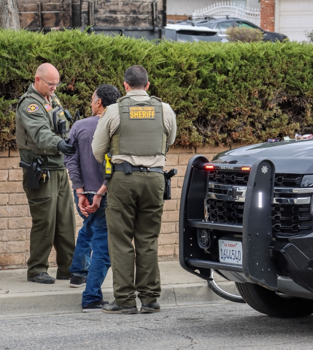 On Friday, February 7, 2025, Gabriel Casa, 44 of Fillmore, was arrested for robbery and assault with a deadly weapon on an adult male victim which occurred in the parking lot of a local market. Photo credit Angel Esquivel. Enlarge Photo By Ventura County Sheriff Department — Thursday, February 13th, 2025
On Friday, February 7, 2025, at approximately 12:30pm, diligent members of the community reported a physical altercation between two individuals in a local market parking lot located in the 1000 block of Ventura Street in Fillmore. Fillmore patrol personnel and detectives with the Fillmore Bureau of Investigation responded to the area and confirmed an assault had occurred and the suspect had fled the scene. Additional resources began to canvass the area for the suspect. A diligent member of the community spotted the suspect who was hiding behind a parked vehicle and flagged down deputies. Deputies located and detained the individual hiding which matched the suspect description. During the subsequent investigation, personnel on scene confirmed the detained person was the suspect, (S) Gabriel Casa. Deputies also learned the victim was not only assaulted by Casa but also robbed of his bicycle. As the investigation unfolded, additional evidence was located in Casa’s possession linking him to the robbery and assault. Gabriel Casa was subsequently arrested for Penal Code § 211 – [Robbery], Penal Code § 245(a)(1) – [Assault with a Deadly Weapon], and Penal Code § 148.9(a) – [Providing False Information to Peace Officer], and misdemeanor drug offenses. Report Number: 25-16243 Location: 1000 block of Ventura Street, Fillmore Date & Time: 02/07/2025, 12:34 PM Unit(s) Responsible: Fillmore Patrol Personnel, Fillmore Bureau of Investigations (S)uspects, (V)ictims, (P)arty, (D)ecedent Prepared by: Sergeant Jarrod Foote |
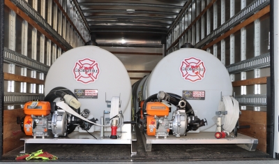
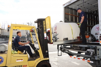
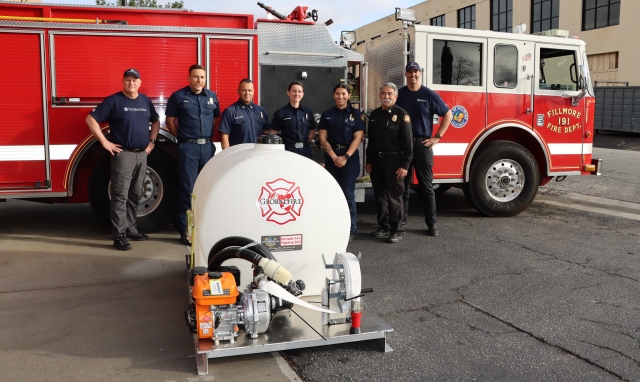 The Fillmore Fire Department has received a 250-gallon water tank and Skidmore pump, donated by GlobalFire of Canada. The tank and pump are a welcomed addition to Fillmore’s exemplary fire department. Photo credit Angel Esquivel. Enlarge Photo By Gazette Staff Writers — Thursday, February 13th, 2025
A 250-gallon water tank and Skidmore pump have been donated to the Fillmore Fire Department by GlobalFire of Canada. According to Fillmore Fire Chief Keith Gurrola, when the Pacific Palisades and Eaton fires broke out a number of these tanks were delivered to Los Angeles, and one was offered to Fillmore. Fillmore Fire already had a 40-gallon tank and pump that they use often, according to Gurrola. “We used it a lot on the 4th of July to put out trash can fires.” Gurrola said the new tank will be loaded into the back of one of the department’s pickup trucks when needed. For instance, during fire season the tank will be loaded, but removed from the truck to make room for sandbags during rainy season. GlobalFire’s mission is to strengthen the emergency response capacity of organizations and communities around the world through the provision of equipment and training. To learn more go to GlobalFire.ca. |
|
By Gazette Staff Writers — Thursday, February 13th, 2025
CITY OF FILLMORE CITY COUNCIL AND SUCCESSOR AGENCY REGULAR MEETING TUESDAY, FEBRUARY 11, 2025, 6:30 PM CITY HALL Meeting of 2-11-2025 All items except for 9.B which resulted in no action taken, passed 5-0. Erika Herrera-Terriquez, City Manager 1. CALL TO ORDER 2. PLEDGE OF ALL-EGIANCE 3. ROLL CALL 4. APPROVAL OF AGENDA 5. PRESENTATIONS 5.A PROCLAMATION PROCLAIMING FEBRUARY AS BLACK HISTORY MONTH 6. PUBLIC COMMENTS 7. CITY COUNCIL REPORTS, RECOMMEND-ATIONS, AND COMMENTS 8. CONSENT CALENDAR RECOM-MENDATION FOR ITEM 8A. THROUGH 8C. IS TO APPROVE BY VOICE VOTE. 8.A CITY OF FILLMORE WARRANT REGISTER-FEBRUARY 11, 2025 CITY OF FILLMORE WARRANT REGISTER-FEBRUARY 11, 2025.PDF 8.B JANUARY 14, 2025 REGULAR CITY COUNCIL MEETING MINUTES JANUARY 14, 2025 REGULAR CITY COUNCIL MEETING MINUTES.PDF 8.C ADOPTION OF ORDINANCE NO. 25-978 TO AMEND SECTION 6.07.060 OF THE FILLMORE MUNICIPAL CODE TO REVISE REGULATIONS FOR SR PUBLIC IMPROVEMENT IMPACT FEE ORDINANCE - NO.25-978.PDF 9. NEW BUSINESS 9.A CONSIDERATION OF AUTHORIZATION FOR AWARD OF CONTRACT FOR FILLMORE FIRE HOUSE ROOF REPLACEMENT PROJECT (PROJECT) SR - FILLMORE FIRE HOUSE ROOF REPLACEMENT PROJECT (1049721.1)_FINAL.PDF RECOMMENDATION That the City Council: 1. Approve a fund transfer in the amount of $18,641.57 to be reallocated from General 9.B CONSIDERATION OF FORMATION OF NEIGHBORHOOD COUNCILS CONSIDERATION OF FORMATION NEIGHBORHOOD COUNCILS SR.PDF 9.C CONSIDERATION OF APPOINTMENT OF ERIKA HERRERA AS CITY MANAGER AND APPROVAL OF CITY MANAGER EMPLOYMENT AGREEMENT CITY OF FILLMORE CM APPOINTMENT SR.PDF 10. COMMITTEE, COMMISSION, AND BOARD REPORTS 11. CITY MANAGER CITY MANAGER VERBAL REPORT 12. CLOSED SESSION 12.A FEBRUARY 11, 2025 - CLOSED SESSION FEBRUARY 11, 2025 - CLOSED SESSION.PDF 13. ADJOURNMENT MAYOR CHRISTINA VILLASEÑOR ADJOURNS TO THE NEXT REGULARLY SCHEDULED MEETING AT 6:30 P.M. ON TUESDAY, FEBRUARY 25, 2025, CITY |
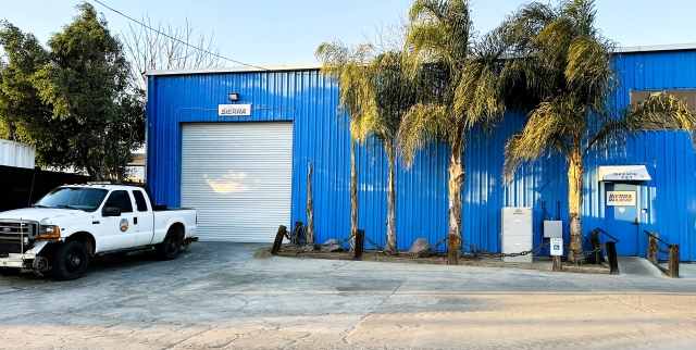 On February 11, 2025, Northern Sierra Railway Ventura Division announced the relocation of its new headquarters to be in Fillmore on 121 Santa Clara Street. Photo credit Northern Sierra Railway. Enlarge Photo By Gazette Staff Writers — Thursday, February 13th, 2025
February 11, 2025 Sierra Northern Railway’s Ventura Division is pleased to announce the recent relocation of its headquarters to Fillmore, Calif. from its former Santa Paula complex. The company provides transportation, rail-served real estate, and railcar storage services. The company owns and operates several rail lines in the state. The new Fillmore facility is located at 121 Santa Clara Street. “This new office and shop provide our employees a relevant facility to serve the railroad and the communities along the line,” said Matt Blackburn, Ventura Division Manager. Another component of the railroad, the Sunburst Train railbike operation, will remain headquartered in Santa Paula at the former Southern Pacific train station. *** The Sierra Northern Railway (reporting mark SERA) is a common carrier railroad company operating in California. The company owns and operates several rail lines originating from those of the former Sacramento Northern Railroad, Northern Electric Railway, Sierra Railway Company of California, Western Pacific Railroad, and Yolo Shortline Railroad. It handles all freight operations and track maintenance for its parent company, the Sierra Railroad Company. The tracks that are maintained by Sierra Northern are also used by the Sierra Railroad Company’s tourist trains For additional information, contact Matt Blackburn at MBlackburn@Sierrarailroad.com. |


